Here’s What it Was Like to Hike the Infamous Knife Edge Trail on Katahdin in Maine
After a failed attempt, I was determined to not only summit Katahdin, but to get there by way of a notably terrifying ascent — or so I’d heard.
I am not new to hiking. I have summited all 48 peaks in New Hampshire that stand over 4,000 feet tall, backpacked rugged terrain on numerous occasions, and currently serve on an Appalachian Mountain Club Committee for — you guessed it, hiking.
Being from New England, there are certain hikes that you just have to do. Even if you’re not someone who considers themselves into hiking, it’s highly likely that you’ve been persuaded into attempting or at least entertaining the idea of at least one of the following popular New England summits: Mount Wachusett (Massachusetts), Mount Monadnock (New Hampshire), Mount Washington (New Hampshire), Franconia Loop (New Hampshire), and Katahdin (Maine). A lot of these peaks are great gateway hikes for folks who unknowingly will spend many future weekends and vacations willingly on a steep, dirty, buggy New England trail.
Katahin had, by default, been on my “list” for many years to accomplish. From the picture’s I’d seen, it’s rugged, Mordor-looking ridge made it otherworldly. It looked tough, it looked spooky, and it looked like I wanted to hike it. I do want to differentiate hiking Katahdin and climbing Katahdin: there are actual rock climbs on this mountain that require a rope, harness, and specific gear, and should not be attempted without hiring a professional guide or an experienced party to guide you.
A few quick facts about Katahdin: it is the Northern terminus for the Appalachian Trail, a 2,194-mile hiking trail that runs from Maine to Georgia, which is the longest hiking-only trail in the world. Katahdin stands 5,269 feet high, and is the highest point in the state of Maine. The name “Katahdin” means “great mountain” and was named by the Penobscot Native Americans.
From where I currently live in Massachusetts, Katahdin is roughly a 6 hour drive, excluding stops. So I began my hiking journey in May of 2021 where all good hiking journeys begin: on the internet.
After some Googling, phone calls and researching, I had learned the following: due to the long drive to and from Katahdin, I’d need to camp a minimum of one night. And because Baxter State Park is very popular in the summer months and there are limited parking spaces and camp sites, I quickly learned that I’d have to book my trip out at least a few months, and made my reservation for a party of one in September.
I headed to the Baxter State Park site and made an out-of-state parking reservation, as well as a one-night tent campsite for the Roaring Brook Campground, which sits at the base of the mountain and a good amount of trailheads. This would be my starting point for hiking the Knife Edge Trail and getting to the summit.
September rolled around and I drove the 6 hours North to the Roaring Brook campground. I rolled up to the Ranger booth behind a short line of cars, and was greeted by a Baxter State Park ranger and a sign that said “Please Shut Off Engine.” I killed the ignition and sat there while they looked up my name. The ranger proceeded to ask me a variety of questions — about pets (not allowed), about alcohol (not allowed), how many are in my party, about pets again, and if I wanted a map or not.
I then drove thirty minutes along a narrow and winding dirt road and watched my cell phone signal disappear completely. I finally saw, at the end of the road, a sign that let me know I had arrived at the Roaring Brook campground. I parked my car, set up my tent, and got ready to get to bed nice and early. Before I was able to turn in for the night, a Ranger approached me and asked me to check-in. She was kind and helpful, wanting to confirm how many people were in my party, and so on. I asked her about hiking the Knife Edge tomorrow, and she half-grimaced.
“It’s supposed to be a bit windy tomorrow,” she explained. “The Knife Edge is about one mile long and pretty exposed, but there are certainly other trails if you’re trying to summit Katahdin. Be sure to check the board in the morning, we’ll have the summit forecast up for you.”
Well, shoot. I really wanted to do the Knife Edge. I mean, how bad could it really be? The truth is, I knew better. I had dealt with temperamental weather many times before — the White Mountains of New Hampshire, where I have done the vast majority of my hiking, are notorious for fast-appearing and severe weather storms. Yet I had driven all this way, taken time off work, and gotten to the foot of the mountain to do this specific hike. I was going to make it work.
4AM comes early, and this day was no exception. I awoke in my tent and shut off my iPhone alarm, with no new notifications for me to distract myself with. I guess it’s time to go.
I rolled out of the tent with my headlamp on, and looked into the pitch black trees surrounding my campsite, looking for reflective eyes. This is a paranoia that I have hoped to have outgrown by now, but at nearly 30 years old, the woods at night still spook me when I’m alone. What can I say? I’m human.
I packed up my tent and made my way to the trailhead, hearing another party of hikers in the distance. They must be gunning for a summit sunrise, which is reserved strictly for folks who are a very specific type of person: choosing, from the cold blackness of your tent, the idea that you might be able to see a nice sunrise over getting the rest of your good night’s sleep is a very hopeful and gritty individual, and I respect it.
After noting the forecast predicted winds, as I’d been warned, I checked into the hiker’s log book:
Name: Michelle
Start time: 4:36AM
Ascent Trail: Helon Taylor
Descent Trail: ?
Ascending the Helon Taylor trail meant I would have to do the Knife Edge in order to summit, and because I was only allowing myself one day to do this, it likely meant that I would only get one shot if I tried this route.

As I started my ascent up Helon Taylor, I was nervous. I listened intently for wind and received nothing but silence in return, save for the roaring brook, as the appropriately named campground had alluded to. I took things slowly, telling myself that I had all day to get the hike done, and steadily followed the LED beam of my headlamp. As time went on, I watched the sky lift from black, to navy, to purple, to deep red. I climbed higher and higher, ascending roughly 1500' before finally turning around to watch the sunrise through the trees — a sunrise that brought me to tears. The trees and rocks around me lit up to a bright red, the sky dark purples, blues, and oranges. I can’t believe I get this all to myself.
Shortly after Mother Nature’s extravagant show, the sun rose above the clouds and left me in a grey, desaturated world. I heard the wind start howling through the trees and I felt my anxiety skyrocket. I then broke tree line and got a terrible feeling in my gut — I’ve felt this kind of weather before, and alpine was really not a place that I wanted to be. But I pressed on, thinking again about all the planning it took to get here. You’re being a chicken.
I ascended more. The sharp, pointed rocks of Katahdin started to come into view, outlined by dark clouds. I looked up at the towering ridge that I was intending on travelling, feeling like I was an intruder on the footsteps of a home that did not want me there — and begrudgingly pressed on.
The gusts blew harder and harder as I took each step. I could now look down into the col of Katahdin and see the wind gusts travel, like a wall across the treetops, before hitting me and nearly knocking me off my feet. The Knife Edge was going to be impossible.
This continued until I made a judgement call: today was not the day I was going to summit Katahdin. It was 7:20AM and I still hadn’t seen a single other person, and my gut told me a simple feeling: no. It was really that simple — I turned around carefully, with tears in my eyes for the second time that day, both trying to get down below alpine and trying to console my ego, which was telling me that I didn’t belong up there, anyways.
Return time: 11:08AM.
In February of 2022, I made my second reservation for Katahdin. I booked two nights at the Roaring Brook campground and an out-of-state parking permit. I’m going to do this no matter what, I said, hoping the weather would be a bit more forgiving on the date I had selected four months in the future.
In June of 2022, I made the drive up again to Millinocket, Maine, and got a campsite directly next to my previous one, and it felt like no time had passed at all.
I met with the on-shift ranger, who I again asked about hiking the Knife Edge. “Tomorrow’s a great day for it!” He exclaimed, and I couldn’t believe that the day I had gambled on four months prior was actually going to work.
Name: Michelle Bourget
Start time: 6:50AM
Ascent Trail: Helon Taylor
Descent Trail: Hamlin Ridge Trail
It all felt very familiar. I remembered each and every turn of the Helon Taylor trail, even though nine months had passed. As I broke alpine, I braced myself for the cruel winds and felt nothing. Anxiety melted away to the feeling of excitement — today was going to be the day. I put on my bug net to deter the swarms of black flies and trudged on.
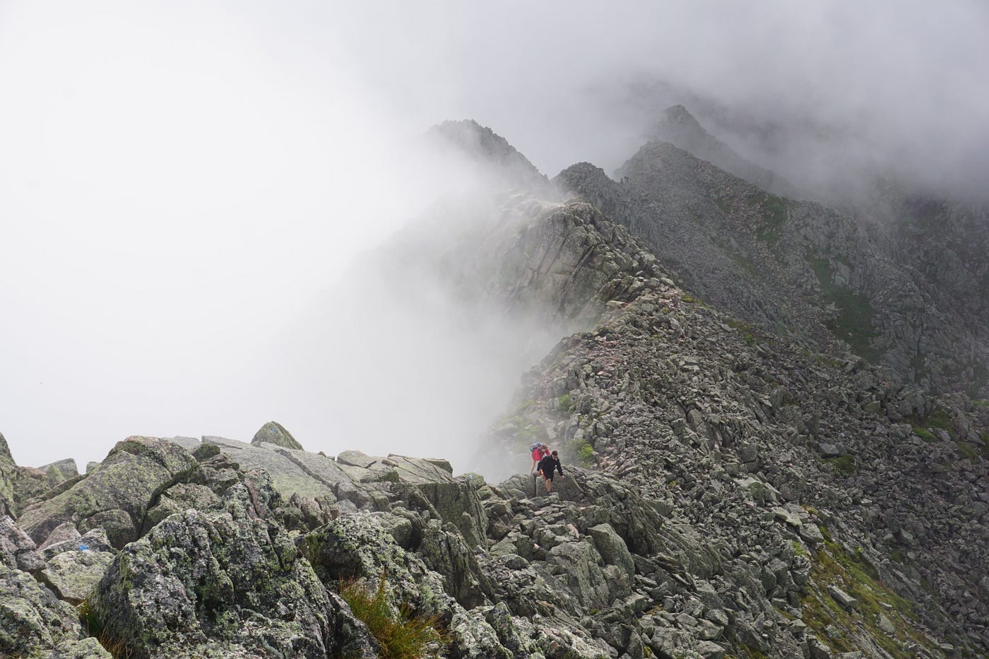
The Helon Taylor trail ascends up a looming staircase of granite. The first checkpoint is Pamola — which the Native Americans said was the protector of the mountain. The summit of Pamola also rewards you with your first view into the col of Katahdin, the Knife Edge trail, and the summit. There are no other words to describe it: it’s breathtaking.
At the summit of Pamola, I met a lovely young couple, Liz and Bobby, who agreed to cross the Knife Edge with me, since it was the first time for all of us. This helped to ease my anxieties greatly. I always boast that I prefer to hike solo — but I’d be lying if I said I wasn’t relieved to have company at that exact moment.
The Chimney is the first section of the Knife Edge — a notch in the ridge which requires scaling 100' down and 100' feet back up. It is unavoidable. I had previously been told by another hiker it was “no big deal,” to which I now ask — to whom? I’ve been a rock climber for nearly ten years, and I had to truly think through the method for which I was going to attempt this section. I hadn’t planned to be intimidated by the Chimney — yet it ended up being the scariest part of the entire hike. I offered to go first out of the three of us, and managed to get down and back up very slowly, often times having to physically turn in and downclimb. There were times where I had to stem my feet out or trust that I wouldn’t completely slip off a handhold. For the novice hiker reading this — the Chimney should not be rushed through and should be taken seriously. I helped guide up Liz and then Bobby as they opted to remove their backpacks and pull them up after with a rope.
After the Chimney was done, you’re able to look at the Knife Edge in it’s entirety in front of you, laid out like a sleeping, scaled dragon. After that, it’s one careful step at a time for 1.1 miles until you reach the summit of Katahdin. And yes, at points it is roughly three feet wide, with substantial (think 2,000 feet) drops on either side, but none of it felt nearly as scary or daring as I had been lead on, and half as scary as the Chimney section. I continued on this slow rock-hop until reaching the summit of Katahdin at around noon.
After snapping some photos and eating a can of pineapple rings (thank me later), I continued over to Hamlin Peak, which is another adjacent 4,000 foot peak that had been on my list. Hamlin was extremely tame compared to Katahdin, and I happily trekked on past the summit and to the descent down Hamlin Ridge Trail.
Hamlin Ridge was very slow going because I was quite tired at this point, but it was worth it for the views looking at Katahdin on the way down. I could see the huge notch that was the Chimney, which looked like something had bitten a piece out of the mountain. I could see the entire jagged course of the Knife Edge, the summit sign, and the well-traveled trail on the way down. I continued this way and saw only one couple, until getting below tree line and eventually connecting with the Chimney Pond trail. This trail was busier than expected, as folks were trekking up in the evening to set up camp at the Chimney Pond campground, accessible only by foot. This trail was also unexpectedly gorgeous — long, winding wood bridges, the fluty sounds of Wood Thrushes, and I even got to see a molting Snowshoe Hare snacking on some tall grass.
I won’t pretend otherwise: this hike exhausted me. I drank all my water (two 32-ounce Nalgene bottles), ate all my food, and was now more than ready for the sweet, peaceful (albeit buggy) campsite I had waiting. My quads were no longer reacting to the brutal descent properly, and I relied heavily on my trekking poles to not roll an ankle or otherwise injure myself when my guard was down. The entire day totaled 11.5 miles, two summits and around 5,000 feet of elevation gain.
When I got back to Roaring Brook Campground, I smiled a tired, emotional smile and couldn’t help but laugh that my biggest accomplishment of the month had been to simply return to the same place I had been this morning in one piece. I signed in to the logbook, feeling whole.
Return Time: 6:20PM.
